Local Geology Day 3
Notes on Geology and Topography of the Birsemore Area
Geology
As might be expected from its position directly between Glen Tanar and Balfour, the bedrock and landscape features of this area are mostly very similar to those of the areas on either side. The bedrock is once again porphyritic granite and, as on the Balfour map, there is ample evidence of channel erosion during repeated meltwater events.
Topography
Unlike either of the other two areas, however, there are significant parts of Birsemore which have been buried under large spreads of sand and gravel. Some of these are flat-surfaced alluvial deposits laid down on river flood plains since the melting of the last ice sheet. The car park and arena for Day 3 make use of one part of the alluvial plain of the Burn of Birse. Another separate part a little further upstream is laid out in fields where arable crops are grown.
The other much more extensive deposits occupy the relatively low-lying ground west and south of the arena between the public road and the lower slopes of Birsemore Hill. This relatively chaotic moundy sand and gravel is the product of melting ice and the numerous transient streams and isolated ice blocks that are associated with this process. On the map, this terrain is characterised by numerous small hills and sinuous ridges separated by marshes and small irregular streams. There is a separate area of terrain like this in the southern part of the map area where the waterlogged conditions similarly result in stunted tree growth and large open patches without any tree cover.
 A low mound of sand and gravel with the granite ridge of Birsemore Hill in the background.
The western half of the Day 3 map is dominated by the prominent ridge known as Birsemore Hill. Here the bedrock mostly lacks any significant cover of sand, gravel or till, the ground-up rock material formed beneath moving ice. Topographic features on the higher parts of the ridge are carved out of granite and once again illustrate how meltwater torrents exploit local weaknesses to create numerous channels, gullies and small hills. Unlike the small hills of gravel on the lower ground, these features often incorporate crags and boulder fields of coarsely crystalline granite. The eastern and western slopes of Birsemore Hill display much less topographic detail due to blanket coverings of rock debris which once formed scree slopes, now largely covered by peaty soil and vegetation.
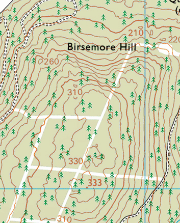
The same description certainly cannot be applied to the challenging north-facing slopes of Birsemore Hill. Here, the serried ranks of crags, the fields of tumbled boulders, and the numerous individual boulders of truly spectacular dimensions all combine to create an impression of a landscape only recently released from the grip of the Ice Age! In simple terms, this side of the hill is a large-scale truncated spur. The former projection of Birsemore Hill into the Dee valley has been sliced off by the main valley glacier(s) to leave a raw unstable rock face that has yet to be subdued by the passage of time and the smoothing effects of prolonged weathering and erosion. Gullies scar the hillside and any channels eroded by meltwater generally proceed headlong straight down the precipitous slopes.
 The steep truncated spur at the N end of Birsemore Hill is illustrated by the concentration of contours on this OS map extract.
The varied challenges of orienteering on the Birsemore map are particularly closely linked to the diverse nature of its terrains. Appreciating the origins of this diversity may – or may not - enhance your experience on Day 3. It all depends on what occupies your mind as you engage with these challenges. Being too interested in landscape features and their origins may be one reason why I for one have never been a leading contender on maps as topographically interesting as Birsemore!
Peter Craig, July 2017