Some Geological and Topographical Notes
These notes have been written for anybody interested in the rocks and landscapes of the Royal Deeside 2017 competition areas. Understanding how various map features were formed may add to your enjoyment of running in these great areas, especially afterwards when you have time to examine the maps in detail and reflect on the many curious and sometimes complex landforms represented on them.
Note that descriptions of maps refer to the full map area and that maps for your particular course may represent only one part of that area.
Summary
The rocks and landscapes that underlie the competition areas for Royal Deeside provide insights into two very different time periods in the Earth’s long history.
The rocks that you will run and scramble over have a history that extends from about 800 to 400 million years ago, an unimaginably long period of time – but still only about one sixth of the age of the planet. The landscape features that have been carved on top of this rocky foundation are mostly much more recent. Many of those that create the more complex areas on the maps are only a few thousand years old, though major landscape features such as the Dee valley itself have probably evolved over an immense time span measured in hundreds of millions of years.
Some of the rocks that you will see as crags and boulders on Days 4, 5 and 6 are the oldest on Deeside. They originally accumulated as sediment on the sea bed off the coasts of continents that drifted ever so slowly in latitudes that took them as far south as the South Pole itself. Other rocks, notably the granite that dominates on Days 1 to 3, were formed later when tectonic movements brought these same continents together in slow motion collisions. The former sediments were transformed into crystalline metamorphic rocks and huge volumes of granite magma pushed upwards through their crumpled layers. This magma cooled and crystallised at depth to form great domes and plumes of granite that are now uncovered and exposed in the hills of Deeside and the high peaks of the Cairngorms and Lochnagar.
Deeside Landscapes
Just as anywhere else, the landscapes you see as you travel through Deeside and run over its hills and through its forests have been shaped by complex interactions between biology, climate, and geology acting over immensely long periods of time. These periods are measured in hundreds of millions of years. However, although people started settling Deeside a mere 6000 years ago, they have already transformed nearly every aspect of the local landscape that you see around you today through agricultural, forestry and game-management practices.
Every aspect, that is, except for the actual shape of the land surface. The topographic details of the map areas you will be competing in during Royal Deeside 2017 are little changed since the last major ice sheet melted away 15,000 years ago. In fact although still not fully understood, there is now strong evidence that the main topographic features go back much further in geological time than that. It is now known that the Ice Age made only relatively minor changes to the overall topography of the land that lies east of the Cairngorms.
The largest local topographic feature is of course the Dee valley itself. The part of the Earth’s crust that is now Scotland was uplifted and tilted slightly eastwards during major volcanic eruptions along the West Coast around 60 million years ago. Several major river systems draining eastward into the North Sea were initiated (or possibly reinvigorated) at this time, including the Don, Spey and Ythan, as well as the Dee. There has been a river carving out what we now call the Dee valley for at least 60 million years. During that time, river erosion has cut down into bedrock to unroof various geological formations making it probable that the detailed course of the river has changed as the river exploited newly exposed less resistant outcrops. The pattern of tributary valleys will also have changed for the same reason.
 The Dee valley as seen from space with the locations of competition venues shown
Deeside Geology
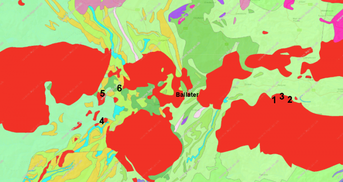
This BGS geological map of upper Deeside shows the complex outcrop pattern of ancient Dalradian metamorphic rocks (shown in shades of green, yellow, blue etc). The red ‘blobs’ represent intrusions of granite which penetrated the Dalradian rocks as magma. Although the granite is present as several separate outcrops at the current level of erosion, these bodies of granite are thought to merge at depth into one huge granite batholith.
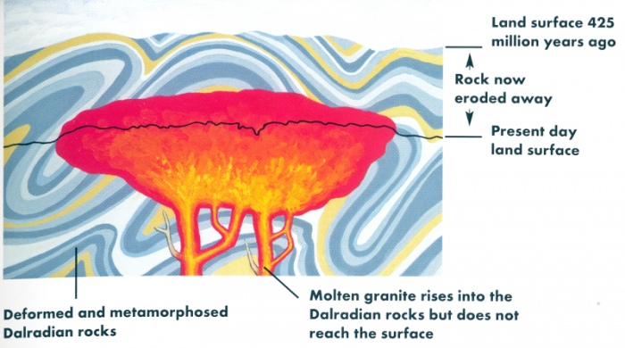
Two areas of high ground that dominate the local landscape have a history that spans an even greater period of time, ever since the intrusion over 400 million years ago of the major granite body that underlies them. The Cairngorms and Lochnagar massifs, along with many other smaller granite intrusions that border the Dee valley, form the topmost parts of a single vast mass of granite known as the East Cairngorms Batholith. There is evidence that several kilometres of older rock that originally covered the top of this batholith were eroded away within only 30 million years of the granite magma cooling and crystallising. In the ensuing 380 million years, it has been calculated that less than two kilometres of granite have been removed by erosion. It is thus probable that the high granite plateaux that characterise the Cairngorms and Lochnagar massifs have formed the western horizon of Deeside for an exceedingly long time.
This diagram (from The Cairngorms – landscapes in stone ISBN 978 1 78027 370 9) illustrates how the erosion of several kilometres of rock has revealed the roof-zone of the large granite intrusion that underlies the Cairngorms.
Among the lower hills, remnants of former erosion surfaces can be made out. One such fragment can be seen forming the top of the Hill of Fare, on the north side of the Dee valley towards Banchory.
The Hill of Fare as seen from above Tarland showing the smooth outline of part of an ancient erosion surface
Geological surveys carried out in recent years have revealed the history of the rocks and landscapes under your feet in Deeside in much greater detail than ever before. These details are summarised very generally in geological notes that follow below for each of the competition areas. They may add a new dimension to your experiences of running over some special parts of Deeside that relatively few visitors make the effort to explore.
Should you wish to learn more about the geological processes that have created the landscapes of Deeside and the Cairngorms National Park, there is an excellent booklet published just this year which provides an easy-to read summary and is illustrated with outstanding photos and diagrams. It is one of the superb Landscapes in Stone series by Alan McKirdy and has the title The Cairngorms.
Another excellent source of geological information is the BGS website, especially the OpenGeoscience section - http://www.bgs.ac.uk/opengeoscience/ . You can browse geological maps, photos, publications - and much more. The BGS mobile app iGeology is a particularly powerful tool for discovering exactly what is under your feet wherever you are. The geological maps used in these notes are sourced from the OpenGeoscience website.
Peter Craig, July 2017

