Location


Final Details
Important Information
- Organising clubs
- MAROC, AYROC, KFO
- Organisers
- Sue Barrie (MAROC)
- Planners
- Nick Hale & Dan Gooch (MAROC)
- Controllers
- David Esson (GRAMP), Phil Smith (AYROC)
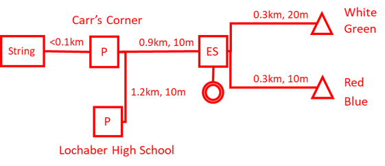
- Directions
- A82 toward Inverness (2 miles). Standard Parking: turn left onto A830 towards Mallaig (0.3 miles) and turn then turn right to Lochaber High School (NN123761). Priority parking: continue on A82 towards Inverness (0.6 miles), turn right into car parking immediately after unlimited speed sign and right hand bend (NN129761) at Carr’s Corner. No right turn on exit.
- Parking (P)
- Hard standing at both locations. Priority parking only for those pre-contacted with priority permits.
- Event Services (ES)
- SE of railway underpass at Fort William Golf Course clubhouse. Access along level tarmac paths from parking, partly on shared cycle path. Follow signed route from Lochaber High Schools using using pedestrian crossings. Do not cross elsewhere. Call-up on the SW edge of the Event Services area.
- Starts
- Along tracks (5 mins)
- Maps
- LIDAR, survey by Peel Land Surveys (2020). 1:10000 for courses 1-2, 1:7500 for courses 3-22. Note that pylons and powerlines are not mapped
- Terrain
- Very mixed terrain ranging from the fast runnable golf course to flattish rough open and scrubby trees with extensive areas of marsh. Oak woodland on steeper slopes with extensive bracken in open areas, Some areas of commercial forestry. Golf greens are OOB. Keep off
- String course
- adjacent to Carr’s Corner
- Safety
- A82 is a busy road – take care crossing. Juniors should be accompanied to and from Carr’s Corner. The steep gorge crossed by the longer routes must be crossed at designated points.
- Junior courses
- White tape used where routes are unclear
- Departure
- No right hand turn on exit from Carr’s Corner.
- Special Info
- Snacks for sale at golf clubhouse. Do not congregate
Course Information
| Course | Class | Length | Climb | Scale | Start |
| 1 | M21E | 5.4 | 205 | 1:10000 | Red |
| 2 | M21L M20L M35L W21E | 4.4 | 155 | 1:10000 | Red |
| 3 | M40L M45L | 4.2 | 160 | 1:7500 | Red |
| 4 | M18L M50L | 3.9 | 145 | 1:7500 | Red |
| 5 | M16A M55L W21L | 3.6 | 135 | 1:7500 | Red |
| 6 | M21S W18L W20L W35L | 3.4 | 130 | 1:7500 | Blue |
| 7 | M60L M20S M35S W40L W45L | 3.5 | 75 | 1:7500 | Blue |
| 8 | M65L M45S M40S W50L | 3.3 | 70 | 1:7500 | Blue |
| 9 | M50S M18S W16A W21S | 2.7 | 100 | 1:7500 | Blue |
| 10 | M70L W55L | 2.8 | 75 | 1:7500 | Blue |
| 11 | M55S W60L | 2.7 | 70 | 1:7500 | Blue |
| 12 | W18S W20S W35S Green | 2.7 | 55 | 1:7500 | Green |
| 13 | M75L M60S W65L W45S W40S | 2.5 | 25 | 1:7500 | Green |
| 14 | M65S W50S | 2.3 | 30 | 1:7500 | Green |
| 15 | M70S W70L W60S W55S | 2.1 | 15 | 1:7500 | Green |
| 16 | M80 M85 M90 M75S W80 W75L W70S W65S | 1.7 | 15 | 1:7500 | Green |
| 17 | W75S W85 W90 | 1.4 | 15 | 1:7500 | Green |
| 18 | M14A M16B | 2.5 | 55 | 1:7500 | Green |
| 19 | W14A W16B Light Green | 1.9 | 55 | 1:7500 | Green |
| 20 | M12A M14B W12A W14B Orange | 1.9 | 25 | 1:7500 | White |
| 21 | M10A M12B W10A W12B Yellow | 1.7 | 15 | 1:7500 | White |
| 22 | M10B W10B White | 1.5 | 5 | 1:7500 | White |
Thanks go to Jahama Highland Estates for permission to stage the event in the vicinity of the GFG Alliance Lochaber smelter. Jahama Highland Estates is a multi-enterprise rural business extending over 114,000 acres of Lochaber and Badenoch. Part of the GFG Alliance, JHE is managed on the principles of sustainable development for the benefit of local communities, the environment, and the economy.


![]()