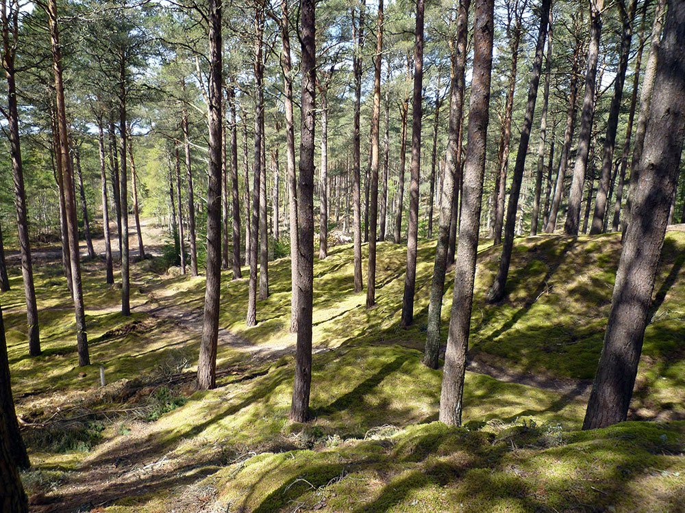
For the final long distance event of Moray 2023 we take you to the delights of Culbin Forest with an arena tucked down below the “raised beach” which borders the forest. Access to the forest from the arena, which will be used for both days, is by kind permission of Davie and Dawn Nicolson and Forestry and Land Scotland.
Culbin was planted between the wars to stabilise shifting sand dunes; the resulting open pine forest on complex topography is perfect for orienteering. The forest is mainly runnable with good visibility though some pockets of gorse and deeper heather do exist. There is very little bracken, or water, and no rock. Hills are not high, but can have short steep faces. Some rides are reasonably clear to follow, but easy to miss on crossing. Some are revealed by having more ground vegetation, so it can be faster to run through the forest beside them.
Recent forestry work has created extraction lanes and vehicle tracks in parts of the area, and there are also traces of older vehicle tracks. In general these are not mapped, although white strips are used to show extraction lanes in some green areas. In fact it can be easier to run beside the extraction lanes rather than along them, because of the brashings and debris on the ground.
Location


Final Details
Important Information
- Organising clubs:
- Edinburgh Southern Orienteering Club (ESOC) supported by Clydeside Orienteers (CLYDE), Kingdom of Fife Orienteers (KFO), East Lothian Orienteers (ELO) and some members of Bristol Orienteering Klub (BOK).
- Organisers:
- Margaret Dalgleish (ESOC) & Jayne McGregor (ESOC).
- Planners:
- Simon Gregersen (ESOC) & Sabine Oechsner (ESOC).
- Controllers:
- Alan Halliday (MOR) & Peter Halling (ESOC).
- Parking:
- Snab of Moy, Kintessack, IV36 2TG.
This parking is not suitable for any campervans or motorhomes whatever their size – it is the ground clearance and weight which means that they will not be permitted to park at Snab of Moy.
All parking for campervans is at Forres Academy Car Park, Burdsyard Road, Forres IV36 1FG with bussing from there. From the bus stop in Kintessack follow the tapes and marshals’ guidance to the Arena which is a 1.2 km walk. - Directions:
- For cars only: From Forres: Follow the A96 west out of Forres. After approximately 3 miles (just before Brodie Countryfare) turn right, over the railway, onto an unclassified road. Continue straight on for 1.1 miles then turn right at the T-junction onto another unclassified road. Follow this road for approximately 2 miles until the turn-off to Snab of Moy farm which is on the left.
For Campervans and Motorhomes: Parking is in the car park at Forres Academy, Burdsyard Road, Forres, IV36 1FG with additional bus transport to the arena. From the Findhorn Roundabout on the A96 take Victoria Road into Forres driving past Grant Park. Take South Street on your left (at the end of Grant Park before Andersons Primary School). At the roundabout take the second exit and immediately turn left onto Sanquhar Road and follow Sanquhar Road for 0.3 miles. Please follow the marshals’ instructions for parking. - Arena:
- Adjacent to parking.
- Starts:
- Red, Blue and Green starts are co-located 3.5 km from the arena.
White start is 2.0 km from the arena. The walk to the starts is on paths and tracks and is almost flat.
There is a clothing dump (at your own risk) roughly 1.7 km from the arena and there are toilets on the way to the Red/Blue/Green starts.
- Terrain:
- Complex contours in forested dune.
- Safety:
- You may encounter walkers, dogs, cyclists and possibly even horses on route to the starts and also whilst on your course. Please take care.
The Finish is remote, please ensure you have planned for this with your juniors.
On the route to the Green, Blue and Red starts, shortly after passing the turn off to the White start, please give way to junior competitors who are competing on their course. - Junior Courses:
- Junior competitors will, on a very short section of their course, encounter people heading to their starts.
- Maps:
- Base map using public access LiDAR data from https://remotesensingdata.gov.scot/.
Original Survey & Cartography of current map, produced for event: Jon Hollingdale, 2022-23. - Finish:
- There is a single finish which is 2 km from the arena. The walk back to arena is on mostly on paths and tracks and is almost flat.
- String and Off-string Courses:
- Adjacent to the Arena.
- Special Information:
- Mapping notes: Areas of deep heather in white forest are indicatively mapped as vegetation slow running (vertical green lines). Thinning lanes in green forest are mapped with a thin white line. Many shallow (<1m) knolls are mapped using small form line shapes (<1.1mm long); larger/steeper knolls use ‘small knoll’ symbol.
See below for more details.
For many controls the feature should strictly be described as “middle”, especially for re-entrants and spurs, because there is so much detail in the circle. We have often used instead what seems to be a more informative description, where there are perhaps two similar features near the centre of the circle – disregarding others at the edges.
Day 4 is part of the UK Orienteering League series. - BOF Registration Number: 81097
Final Course Lengths
| Course | Class | Length (km) | Climb (m) | Map Scale | Start |
| 1 | M10B W10B | 1.7 | 20 | 1:7,500 | White |
| 2 | M10A M12B W10A W12B | 2.9 | 35 | 1:7,500 | White |
| 3 | W12A W14B | 3.3 | 50 | 1:7,500 | White |
| 4 | M12A M14B | 3.6 | 50 | 1:7,500 | White |
| 5 | W75S W85 | 2.1 | 40 | 1:7,500 | White |
| 6 | M85 W70S W80 | 2.2 | 40 | 1:7,500 | White |
| 7 | M75S M80 W65S W75L | 2.4 | 40 | 1:7,500 | White |
| 8 | White | 1.7 | 20 | 1:7,500 | White |
| 9 | Yellow | 2.9 | 35 | 1:7,500 | White |
| 10 | Orange | 3.3 | 50 | 1:7,500 | White |
| 14 | Light Green | 3.5 | 55 | 1:7,500 | Green |
| 15 | Green | 4.5 | 70 | 1:10,000 | Green |
| 16 | W14A W16B | 3.5 | 50 | 1:7,500 | Green |
| 17 | M14A M16B | 4.5 | 75 | 1:7,500 | Green |
| 18 | M70S W55S W60S W70L | 3.4 | 70 | 1:7,500 | Green |
| 19 | M65S W50S | 3.7 | 65 | 1:7,500 | Green |
| 20 | M75L W45S W65L | 4.2 | 80 | 1:7,500 | Green |
| 21 | M60S W40S | 4.3 | 70 | 1:7,500 | Green |
| 22 | W18S W20S W35S | 4.5 | 70 | 1:10,000 | Green |
| 23 | M55S W60L | 4.7 | 80 | 1:7,500 | Blue |
| 24 | M70L W55L | 5.2 | 110 | 1:7,500 | Blue |
| 25 | M18S W16A W21S | 5.2 | 75 | 1:10,000 | Blue |
| 26 | M50S | 5.5 | 105 | 1:7,500 | Blue |
| 27 | M45S W50L | 5.6 | 90 | 1:7,500 | Blue |
| 28 | M40S M65L | 5.8 | 120 | 1:7,500 | Blue |
| 29 | M20S M35S W45L | 5.8 | 130 | 1:7,500 | Blue |
| 30 | M60L W40L | 6.4 | 125 | 1:7,500 | Blue |
| 31 | M21S W18L W20L W35L | 6.7 | 130 | 1:10,000 | Blue |
| 34 | M16A W21L | 6.8 | 130 | 1:10,000 | Red |
| 35 | M55L | 7.1 | 125 | 1:7,500 | Red |
| 36 | M18L M50L | 7.9 | 140 | 1:10,000 | Red |
| 37 | M45L | 8.5 | 140 | 1:10,000 | Red |
| 38 | M40L | 8.7 | 140 | 1:10,000 | Red |
| 39 | M20L M21L M35L | 8.8 | 140 | 1:10,000 | Red |
| 40 | W21E | 8.7 | 150 | 1:10,000 | Red |
| 41 | M21E | 10.9 | 190 | 1:10,000 | Red |
Thanks to the landowners who have made today’s event possible…
 |
|
| Forestry and Land Scotland | Dawn and Davie Nicolson |
Mapping Notes
ISOM 531 “Prominent man-made feature – X” is used for significant wooden platforms and shelters. NB many small dens and temporary structures are not mapped.
Roadside gorse has only been mapped where it is dense enough to significantly impede progress.
 Culbin’s sand dune topography includes many thousands of small knolls, most of which are between 0.5m and 1.5m high. Whilst the specification sets a minimum height of 1m, in practice it is impossible for a runner at speed to distinguish between 0.9m and 1.1m knolls, especially on a slope, and a map that only included the latter would be unhelpful.
 Larger and steeper knolls have been mapped using ISOM 109 “small knoll”
Shallower knolls are generally mapped with form lines: these are by necessity sometimes smaller than the specified minimum length of 1.1mm.
ISOM 113 “broken ground” has only been used where unavoidable
 Culbin is a working forest and is subject to regular thinning operations which have left many machinery lanes.
These thinning lanes are mapped in areas of green forest using a thin (0.4mm) white line to avoid obscuring the contour detail.
Thinning and extraction lanes in white forest are not mapped
 Areas of white forest with deep heather have been mapped using ISOM 407: vegetation slow running, good visibility” (vertical green lines). This is primarily intended to inform route-choice: the vegetation screen shows where the heather is an impediment to running, rather than the complete extent of heather and should not be relied on for fine navigation.
 Distinct vegetation boundaries are shown using a green dashed line.
These are generally only marked where there is a clear boundary between blocks of a single colour, e.g. there is an obvious change from conifer to broadleaf but both areas are mapped using ISOM 406 “slow running”.